


|
|
|---|
 Panorama image made by 3 shots.
 Breidalsvatnet - Oppland
 Møre og Romsdal
 Møre og Romsdal
 Rauma - Møre og Romsdal
 Dalsnibba - Geiranger - Møre og Romsdal - 1500m above see level
Situated in Møre og Romsdal county, Norway, Atlanterhavsveien (lit. The Atlantic Road) is the part of National Road No. 64 (RV 64) that connects the island of Averøy to Vevang, Eide, on the mainland; by extension, the road connects the cities of Kristiansund and Molde.
Construction work on the road started on August 1, 1983, with the opening taking place on July 7, 1989. During this period there were no less than 12 hurricanes in the area. The 8.3 km(5 mile) long road is built on several small islands and skerries, and is spanned by eight bridges and several landfills.
This road has an open sea view which is not so common for roads along the Norwegian coast, since there are archipelagos that obscures this view. Here the distance between the islands is so small that a road could be built across the archipelago. In addition there are fjords and mountains inside the road.
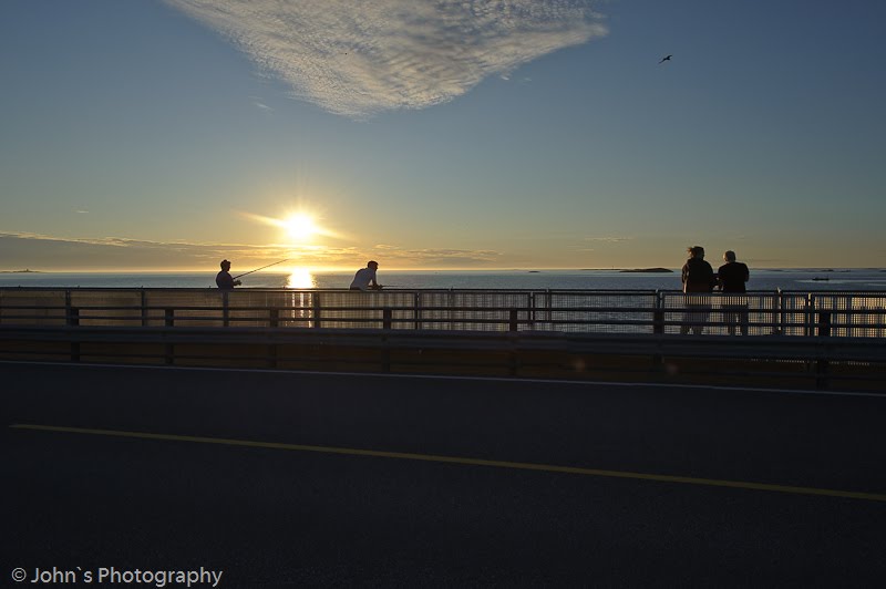
The spectacular road quickly became a popular tourist attraction to the extent that caution must be shown when driving it, as both the local population and visitors frequently use the road to go fishing for cod and other saltwater fish directly from the roadside.
Atlanterhavsveien was voted "Norwegian Construction of the Century" on 27 September 2005, and is currently Norway's second most visited scenic road after Trollstigen (also in Møre og Romsdal). Atlanterhavsveien's sharp turns and wild nature have ranked it first on The Guardian's list of the world's best road trips, in sharp competition with world renowned attractions such as Northern Ireland's Antrim coast road and the Himalayas.
 Storseisundet Bridge (Storseisundet bru) is the longest of the 8 bridges that make Atlanterhavsveien ("The Atlantic Road"), the road connection from the mainland to Averøy in Møre og Romsdal county in Norway. Storseisundet Bridge is a cantilever bridge, 260 metres long and with a maximum clearance to the sea of 23 metres.


Ålesund is a city and municipality in the county of Møre og Romsdal, Norway. It is a sea port, and is noted for its unique concentration of Jugendstil architecture.
Ålesund was established as a municipality January 1, 1838. Borgund was merged with Ålesund January 1, 1968. Sula was separated from Ålesund January 1, 1977. Ålesund received city rights in 1848. It is the administrative center as well as the principal shipping city of the Sunnmøre district. The Ålesund agglomeration has a population of 45,299.
Ålesund was originally known as Kaupangen Borgund, kaupang being Norse for marketplace or town. The West Norse form of the current name was Álasund. The first element is (probably) the plural genitive case of áll m 'eel', the last element is sund n 'strait, sound'.


Geiranger is a small tourist town in the western part of Norway in the region called Sunnmøre in the municipality of Stranda. It lies at the head of the Geirangerfjord, which is a branch of the Storfjord. The nearest city is Ålesund. Geiranger is home to some of the most spectacular scenery in the world, and has been named the best travel destination in Scandinavia by Lonely Planet. Since 2005, the Geirangerfjord has been listed as a UNESCO World Heritage Site.
Norway's third biggest cruise-ship port receives 140 - 180 ships during the four-month tourist season. Several hundred thousand people pass through every summer, and tourism is the main business for the 250 people who live there permanently. There are five hotels and over ten camping sites. The tourist season stretches from May to early September; in the off-season the pace and activity are reduced to that of a normal small Norwegian town.
Each year in June, the Geiranger - From Fjord to Summit event occurs. It comprises a half marathon run and a bicycle race, both starting from the sea level at the fjord and ending at the 1,497 m (4,843 ft) summit of Mount Dalsnibba. As there is still a lot of snow left in the mountains at that time of year, the race could also be called From Summer to Winter.
Geiranger is under constant threat from the mountain Åkerneset which could erode into the fjord. A collapse could cause a tsunami that could destroy downtown Geiranger.


 M/S NordNorge
 Geirangerfjord - Sightseeing boat

 The Geirangerfjord (Geirangerfjorden) is a fjord in the Sunnmøre region, located in the southernmost part of the county Møre og Romsdal in Norway. It is a 15km long branch of the Storfjord (Great Fjord). At the head in the fjord lies the small village of Geiranger.
The fjord is one of Norway's most visited tourist sites and has been listed as a UNESCO World Heritage Site, jointly with Nærøyfjord, since 2005, although this status is now threatened by the disputed plans to build power lines across the fjord.
The Geirangerfjord is under constant threat from the mountain Åkerneset which is about to erode into the fjord. A collapse would produce a tsunami, hitting several nearby towns including Geiranger and Hellesylt in about ten minutes.
Along the fjord's sides there lie a number of now abandoned farms. Some restoration has been made by the 'Storfjordens venner' association (see external link below). The most commonly visited among these are Skageflå, Knivsflå, and Blomberg. Skageflå may also be reached on foot from Geiranger, while the others require a boat excursion. The fjord is also host to several impressive waterfalls.
A car ferry, which doubles as a sightseeing trip, is operated by Fjord1. It runs lengthwise along the fjord between the towns of Geiranger and Hellesylt.

The Seven Sisters (no: Syv Søstre, or Syv Systre) is a waterfall consisting of seven separate streams in Geirangerfjord, Norway. The tallest one has a free fall that measures 250 meters.
The legend of the seven sisters is that they dance playfully down the mountain, while the couurtier (a single waterfall opposite of the seven sisters) flirts playfully from across the fjord.

 The Seven Sisters (left) and the Suitor (right).


 Hellesylt is a small village in the municipality of Stranda, Norway. Its population as of 2007 is about 600. Hellesylt lies at the head of the Sunnylvsfjord, which is a branch of the Storfjord (Great Fjord), and which the more famous Geirangerfjord in turn branches off nearby. In the summertime, thousands of tourists travel through or stay at Hellesylt each day. Most of them take the ferry to Geiranger, which in high season runs every half an hour. The village is surrounded by mountains and valleys.
 Hellesylt Waterfall


